 |
|||||||||||||||||||||||||||||||||||||||||||||||||||||||||||||||||||||||||||||||||||||||||||||||||||||||||||||||||||||||||
|
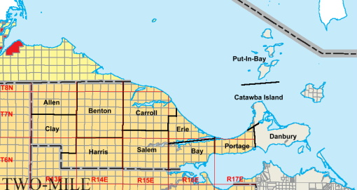
Places:Townships Ottawa County Townships Political Townships - Ottawa County consists of the following Townships:
Township boundaries are approximately in the following
locations,
Map background: Ohio Department of Natural Resources, Division of Geological Survey Land surveyed in the western part of Ottawa county is a part of the 1819-20 Congress Lands survey, land in the eastern portion is a part of the Firelands Grant of the Connecticut Western Reserve. The northern boundary of Ottawa County follows the "Fulton Line", the original boundary between Ohio and Michigan. Land to the north of the Fulton Line is based on the Michigan land survey of 1815. See more information on: Markings on the map above are approximate. It and the discussion above are intended for genealogical purposes only and are not meant to be an in-depth reference on this topic. Governmental township and section maps should be utilized to determine the exact location of property. Please advise the County Coordinator should it be found that any sections are shown in the wrong township. Surveyed Townships - Legal Descriptions Legal descriptions of the surveyed townships do not always correspond to the political townships, especially where the political townships are not six miles square. Townships are identified by their location relative to central "meridians", which run north-south and "baselines", which run east-west in each survey tract. Legal townships are referred by rows of "Townships" north or south of the reference meridian and by "Ranges" east or west of the reference. E.g., a section of land may be known as "Township 7 North, Range 14 East, Section 1". On the above map, it would be located within the political township of Benton.
Population - 1990 & 2000 Census - by entity
Ottawa County Census 2000 Quick Facts This site (c) 2005-2017. |
||||||||||||||||||||||||||||||||||||||||||||||||||||||||||||||||||||||||||||||||||||||||||||||||||||||||||||||||||||||||